


BLOG / SOLUTIONS · MOBILE WORKFORCE MANAGEMENT
3 THINGS TO KNOW ABOUT GEOCODING AND MOBILE WORKFORCE MANAGEMENT
Share post
5 min. reading time
24 June 2021 · James Alex Waldron
24 June 2021 · James Alex Waldron
M
obile Workforce Management is the practice of allocating and reacting to the activities of field resources through a permanent data connection to your operations software. To optimise a mobile workforce means these resources (people, stock, and vehicles) are balanced between meeting SLAs, such as appointment times, and an acceptable quality of work, such as a first-time fix. It is only through an optimised balance that a business provides a sensible, scheduled workload for their field force, whilst remaining competitive.
Amongst the hundreds of possible data points to assist this optimisation—inventory, operative skills, and job completion analytics, (the list is ever growing)—all would be rendered useless without geolocation. What is the power of data-driven positioning, how has it evolved into code, and what does it mean for decision making in mobile workforce management? Here we introduce the concept and look at an example solution.
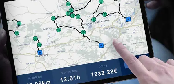
Best-of-breed scheduling software, such as FLS VISITOUR, computes these additional properties in two ways. The first evolves multiple geolocation datasets into unique geocodes. The second is to combine those geocodes into one software. Simply put, to truly optimise scheduling, highly detailed location data becomes code, and the FLS VISITOUR GIS Server and Dispatching Server is uniquely, a single programme to process that code.
Tracking geocode data from mobile resources (people/vehicles in the field) into live maps allows planners to remove hard borders (patches) in favour of an overlapping radius. Old-fashioned service patches lead to unbalanced workloads for mobile workforces and inefficient routing when plans change. Scheduling within a radius results in less travel, a lower carbon footprint, and a happier field workforce.
Again, no reliance on third-party interfaces, such as calls to Google Maps, what3words, or even open source plugins, means scheduling within seconds, on one screen. More data built on geocode foundations, such as traffic jams and ongoing roadworks (like Britain’s 'Smart Motorways' effort) are instantly factored into scheduling results. Based on these parameters, FLS VISITOUR always calculates the fastest route, never the shortest. Reducing human involvement with administration means published routes can be clearly explained – and relied upon by your mobile workforce.
Amongst the hundreds of possible data points to assist this optimisation—inventory, operative skills, and job completion analytics, (the list is ever growing)—all would be rendered useless without geolocation. What is the power of data-driven positioning, how has it evolved into code, and what does it mean for decision making in mobile workforce management? Here we introduce the concept and look at an example solution.
THE BASICS: WHAT IS GEOLOCATION?
Geolocation in its rawest form is real-world location data. It has numerous use cases, covering planning, engineering, transport, logistics, insurance, telecommunications, and sales. Location-enabled field service apps are supplied data through a technical standard served by a Geographic Information System (GIS). This data feeds positioning into both applications of the scheduling relationship; dispatch (a scheduling server) and device (live field results). The combined business benefits of geolocation data is growing exponentially, with increased use of assistive devices in engineering, and the Internet of Things powering performance metrics for predictive maintenance.WHAT IS GEOCODING IN MOBILE WORKFORCE MANAGEMENT?
However, solely using address data, such as a Post Code/ZIP Code is not optimal. It simply cannot account for the limitless variations that affect meeting a scheduled appointment time successfully. Intelligent scheduling conditions include road type, road length; even whether the address is on the left or right-hand side of the road or crosses a body of water.Best-of-breed scheduling software, such as FLS VISITOUR, computes these additional properties in two ways. The first evolves multiple geolocation datasets into unique geocodes. The second is to combine those geocodes into one software. Simply put, to truly optimise scheduling, highly detailed location data becomes code, and the FLS VISITOUR GIS Server and Dispatching Server is uniquely, a single programme to process that code.
HOW DOES GEOCODING OPTIMISE MOBILE WORKFORCE MANAGEMENT?
A system missing location intelligence cannot define travel speed, realistic distance, or arrival times. Therefore, geocoding must be the basis for optimising the entire routing and dispatch process. FLS VISITOUR goes further. The PowerOpt scheduling algorithm consults many intuitive features built with geocodes, such as FLS Speed Profiles. Identifiers such as house numbers, junctions, one-way streets, and time-of-day driving data for trillions of journeys all contain geocode elements and are considered in routing results.Tracking geocode data from mobile resources (people/vehicles in the field) into live maps allows planners to remove hard borders (patches) in favour of an overlapping radius. Old-fashioned service patches lead to unbalanced workloads for mobile workforces and inefficient routing when plans change. Scheduling within a radius results in less travel, a lower carbon footprint, and a happier field workforce.
Again, no reliance on third-party interfaces, such as calls to Google Maps, what3words, or even open source plugins, means scheduling within seconds, on one screen. More data built on geocode foundations, such as traffic jams and ongoing roadworks (like Britain’s 'Smart Motorways' effort) are instantly factored into scheduling results. Based on these parameters, FLS VISITOUR always calculates the fastest route, never the shortest. Reducing human involvement with administration means published routes can be clearly explained – and relied upon by your mobile workforce.
WHAT CAN GEOCODING SOLVE IN PRACTICE?
Consider this. An electrical engineer must travel to inspect a pylon in the countryside, as soon as possible. They must meet the scaffolding supplier at the correct pylon. There are 30 pylons in the service area.For the engineer dispatched by static Gantt chart and simple geolocation:
- There is no apparent availability today. An appointment tomorrow is cancelled to make room for this visit.
- They are sent to the front gate of the property, which is the postal address and offers no access to the area.
- They must locate the pylon by scanning barcodes on a scanning device.
- They must send an SMS to the dispatch desk to say they’ve arrived.
- They open an email with the ticket.
- They send an email to log the work and leave the site.
- The next customer is awaiting their visit, and only knows the engineer will arrive within the next six hours.
For the scaffolding supplier using the geocoding features of FLS VISITOUR and FLS MOBILE:
- The dispatch manager receives the ticket via their CRM into FLS VISITOUR. They click schedule and the system finds two nearby operatives.
- The algorithm reworks the routes according to operatives’ skills and creates availability today. The customer is notified automatically and accepts the appointment on a self-service portal.
- The scaffold builder is directed to the correct gate in the fastest time possible, having been given a route away from a road closure.
- Using FLS MOBILE they notify dispatch of their arrival and are guided to the pylon by geocode.
- They have the ticket detail fed directly from the CRM to FLS MOBILE.
- They take a photo of their work and attach it to the ticket.
- They notify FLS VISITOUR that their appointment is complete. FLS VISITOUR gives them their next route and notifies the next appointment with a one-hour window. That customer can track the operative's live location on a map.
HOW TO REQUEST A DEMO OF THE GEOCODING FOR OPTIMISED MOBILE WORKFORCE MANAGEMENT
To gain an understanding of tools to improve the field experience for your workforce, book a short demo or contact us at info@fastleansmart.com.Read more:
Rethinking Field Service Apps for excellent customer experiences
Winning with Field Service Management apps
11 reasons to professionalise your Route Planning

Author
JAMES ALEX WALDRON
UK Marketing Manager
+44(0) 1183 800189
Send email
James Alex Waldron has worked in written communications for over 10 years. Since 2021, he has written for FLS and the Solvares Group on the topics of digital field service transformation and mobile workforce manageMent, and regularly provides insight to the industry press.
DO YOU HAVE AN EXTRA MOMENT?
20. July 2023

20.07.2023 BLOG / SOLUTIONS – James Alex Waldron: The first step is to audit your existing processes. Working with stakeholders […]
12. December 2023

12.12.2023 BLOG / SOLUTIONS – James Alex Waldron: Field Service: Dynamic Route Planning to Net Zero Fleet technology, Capacity Planning […]
16. May 2023

16.05.2023 BLOG / SOLUTIONS – James Alex Waldron: Add critical Kerbside Data to FLS VISITOUR route & tour planning for […]